Welcome, Kapamilya! We use cookies to improve your browsing experience. Continuing to use this site means you agree to our use of cookies. Tell me more!
PAGASA says 'Dante' moves towards Batangas, no longer mentions possible Bataan landfall
ABS-CBN News
Published Jun 02, 2021 06:49 PM PHT
|
Updated Jun 03, 2021 02:07 AM PHT
Photo courtesy of PAGASA
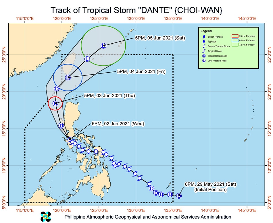
MANILA (UPDATED)— Tropical Storm Dante (international name: Choi-wan) on Wednesday night moved towards the southwestern coast of Batangas, the weather bureau said in its latest bulletin, which also did not mention anymore about a possible landfall over Bataan as earlier projected.
In its 8 p.m. update, PAGASA warned that the storm could pass "near or in the vicinity" of the southwest areas in Batangas on Wednesday evening, as well as over the portions of Bataan and Zambales on Thursday morning.
Dante, the Philippines' fourth storm this year, made its 6th landfall over Pola, Oriental Mindoro at 2 p.m.
It sped up on Wednesday evening, moving west northwestward at 20 kph.
ADVERTISEMENT
"It will then emerge over the West Philippine Sea [Thursday] morning," the latest bulletin read.
Dante was last spotted over the coastal waters of Calapan, Oriental Mindoro as of 7 p.m., and was packing maximum sustained winds of 65 kilometers per hour (kph) near the center, with gusts of up to 90 kph.
Dante has so far left 3 people dead, and nearly P15 million worth of damage in agriculture after lashing Mindanao and parts of Visayas, relevant agencies said.
Tropical cyclone wind Signal No. 2 was hoisted over the following areas:
LUZON
the northern portion Oriental Mindoro (Naujan, Baco, San Teodoro, Puerto Galera, City of Calapan, Victoria)
the northern portion Occidental Mindoro (Paluan, Abra de Ilog, Mamburao, Santa Cruz)
Lubang Islands
Batangas
Cavite
Bataan
the southwestern portion of Bulacan (Calumpit, Bulacan, City of Malolos, Paombong, Hagonoy)
the western portion of Pampanga (Masantol, Macabebe, Sasmuan, Lubao, Floridablanca, Porac, Guagua, Santa Rita, Angeles City, Mabalacat City, Minalin, Bacolor)
Zambales
the western portion of Tarlac (Bamban, Capas, San Jose, Mayantoc, Camiling, Santa Ignacia, San Clemente)
the western portion of Pangasinan (Bolinao, Anda, Bani, Agno, Burgos, Infanta, Dasol, City of Alaminos, Mabini, Sual, Labrador, Bugallon, Aguilar, Mangatarem, Bayambang, Urbiztondo, Basista, Malasiqui, San Carlos City, Santa Barbara, Mangaldan, Dagupan City, Calasiao, Binmaley, Lingayen)
The following areas were placed under tropical cyclone wind Signal No. 1:
ADVERTISEMENT
LUZON
Metro Manila
Marinduque
the northern portion of Romblon (Banton, Concepcion)
the rest of Oriental Mindoro
the rest of Occidental Mindoro
the western portion of Quezon (Sampaloc, Lucban, City of Tayabas, Dolores, Tiaong, San Antonio, Candelaria, Sariaya, Lucena City, Pagbilao, Padre Burgos, Agdangan, Atimonan, Unisan, Plaridel)
Laguna
Rizal
the rest of Bulacan
the rest of Pampanga
the rest of Tarlac
the western portion of Nueva Ecija (Science City of Muñoz, Lupao, Cuyapo, Talugtug, Guimba, Nampicuan, Quezon, Licab, Santo Domingo, Talavera, Cabanatuan City, Santa Rosa, Aliaga, Zaragoza, Jaen, San Antonio, Cabiao, San Isidro, San Leonardo, City of Gapan, Peñaranda)
the rest of Pangasinan
the southern portion of Benguet (Itogon, Tuba, Sablan, Baguio City, La Trinidad, Kapangan, Tublay)
La Union
Photo courtesy of PAGASA
Moderate with at times intense rains may be experienced in the areas of Cavite, Batangas, Romblon, Marinduque, Occidental Mindoro, Oriental Mindoro, Bataan, Zambales, and Pangasinan from Wednesday night until Thursday afternoon.
The rest of Central Luzon, Calabarzon, the northern portion of Palawan including Calamian, Cuyo, and Cagayancillo Islands, and the northwestern portion of Aklan and Antique, meanwhile, can experience moderate to heavy rains during the same period.
Light to moderate with at times heavy rains may be experienced over the areas of Metro Manila, Camarines Norte, Camarines Sur, La Union, Ilocos Sur, Mountain Province, Kalinga, Abra, Benguet, Nueva Vizcaya, Quirino, and the rest of Mimaropa, according to PAGASA.
"Under these conditions and considering antecedent rainfall, scattered to widespread flooding, including flash floods, and rain-induced landslides are expected, especially in areas with high or very high susceptibility to these hazards as identified in hazard maps" PAGASA said.
The weather agency forecast Dante to weaken into a tropical depression Wednesday night or Thursday morning "due to land interaction with the rugged terrain of mainland Luzon."
ADVERTISEMENT
It can further weaken into a low pressure area by Saturday, according to the agency.
ABS-CBN is the leading media and entertainment company in the Philippines, offering quality content across TV, radio, digital, and film. Committed to public service and promoting Filipino values, ABS-CBN continues to inspire and connect audiences worldwide.
Our website is made possible by displaying online
advertisements to our visitors. Please consider supporting
us by disabling your ad blocker on our website.
Our website is made possible by displaying online
advertisements to our visitors. Please consider supporting
us by disabling your ad blocker on our website.