Signal No. 1 up in parts of Northern Luzon, as Karding intensifies further
ADVERTISEMENT

Welcome, Kapamilya! We use cookies to improve your browsing experience. Continuing to use this site means you agree to our use of cookies. Tell me more!
Signal No. 1 up in parts of Northern Luzon, as Karding intensifies further
ABS-CBN News
Published Sep 24, 2022 07:36 AM PHT
MANILA - Tropical Cyclone Wind Signal No. 1 was raised over several areas in the northern part of Luzon as Tropical Storm Karding (international name: Noru) further intensifies, state weather bureau PAGASA said Saturday.
MANILA - Tropical Cyclone Wind Signal No. 1 was raised over several areas in the northern part of Luzon as Tropical Storm Karding (international name: Noru) further intensifies, state weather bureau PAGASA said Saturday.
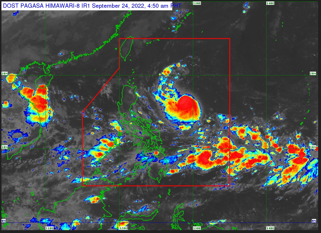
In its 5 a.m. weather bulletin, PAGASA said Karding was last sighted 795 km east of Tuguegarao City, moving west southwestward at 15 kilometers per hour (kph) while packing maximum sustained winds of 85 kph near its center with 105 kph gusts.
In its 5 a.m. weather bulletin, PAGASA said Karding was last sighted 795 km east of Tuguegarao City, moving west southwestward at 15 kilometers per hour (kph) while packing maximum sustained winds of 85 kph near its center with 105 kph gusts.
It is expectd to bring lght to moderate with at times heavy rains over Batanes, Cagayan, Isabela and the northern portion of Aurora from Saturday night to early Sunday, while heavy to intense rains may persist over the northern portion of Aurora, Isabela, Quirino, Nueva Vizcaya, Benguet, La Union, Pangasinan, and the northern portion of Nueva Ecija from Sunday through Monday.
It is expectd to bring lght to moderate with at times heavy rains over Batanes, Cagayan, Isabela and the northern portion of Aurora from Saturday night to early Sunday, while heavy to intense rains may persist over the northern portion of Aurora, Isabela, Quirino, Nueva Vizcaya, Benguet, La Union, Pangasinan, and the northern portion of Nueva Ecija from Sunday through Monday.
Moderate to heavy rains are also expected over mainland Cagayan, Ilocos Provinces, the rest of Nueva Ecija, Tarlac, the northern portion of Zambales, and the rest of Cordillera Administrative Region, while light to moderate with at times heavy rains may prevail over the rest of Cagayan Valley and Central Luzon.
Moderate to heavy rains are also expected over mainland Cagayan, Ilocos Provinces, the rest of Nueva Ecija, Tarlac, the northern portion of Zambales, and the rest of Cordillera Administrative Region, while light to moderate with at times heavy rains may prevail over the rest of Cagayan Valley and Central Luzon.
ADVERTISEMENT
Signal No. 1 has been hoisted over the following areas:
Signal No. 1 has been hoisted over the following areas:
- Isabela
- Nueva Vizcaya
- Quirino
- southern portion of mainland Cagayan (Peñablanca, Tuguegarao City, Iguig, Solana, Tuao, Enrile)
- Kalinga
- Mountain Province
- Ifugao
- Aurora
- northern and eastern portions of Nueva Ecija (Carranglan, Pantabangan, Gabaldon, Bongabon, Laur, Rizal, San Jose City, Lupao, Llanera, General Mamerto Natividad, Palayan City, General Tinio)
PAGASA also said Southern Luzon, including Metro Manila, and Visayas may experience occassional rains due to the southwest monsoon, partially influenced by Karding.
PAGASA also said Southern Luzon, including Metro Manila, and Visayas may experience occassional rains due to the southwest monsoon, partially influenced by Karding.
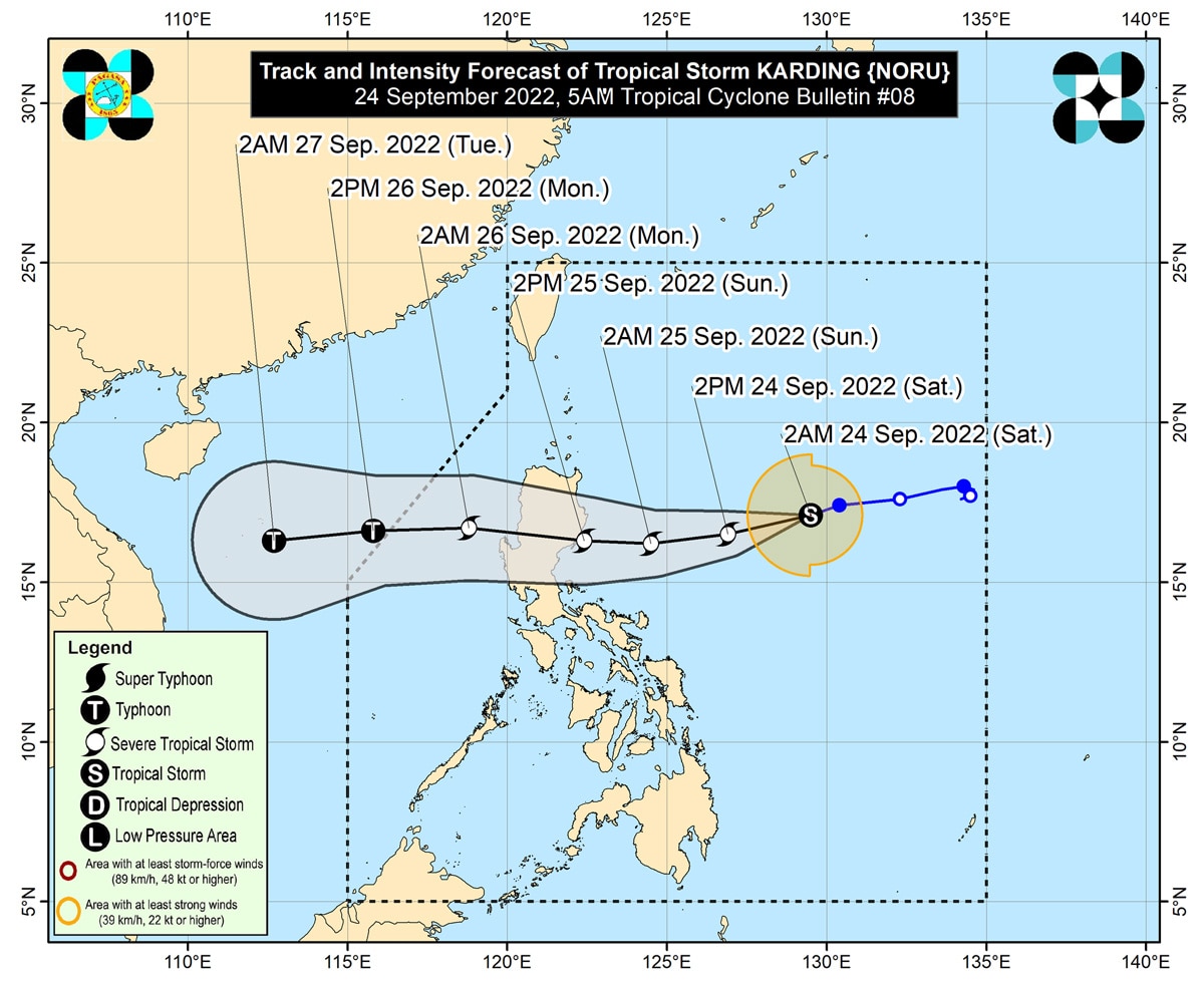
Karding is expected to continue moving west southwest or westward while gradually accelerating towards the east coast of Isabela or Aurora, where it is expected to make landfall Sunday morning or afternoon.
Karding is expected to continue moving west southwest or westward while gradually accelerating towards the east coast of Isabela or Aurora, where it is expected to make landfall Sunday morning or afternoon.
After crossing the mountainous terrain of Northern Luzon, it is expected to emerge over the West Philippine Sea late Sunday or early Monday.
After crossing the mountainous terrain of Northern Luzon, it is expected to emerge over the West Philippine Sea late Sunday or early Monday.
While current forecast scenario shows Karding may make landfall as a severe tropical storm, PAGASA said there is still a possibility that Karding may reach typhoon category before making landfall.
While current forecast scenario shows Karding may make landfall as a severe tropical storm, PAGASA said there is still a possibility that Karding may reach typhoon category before making landfall.
ADVERTISEMENT
ADVERTISEMENT


