Signal no. 3 raised in more areas as Ompong nears | ABS-CBN


ADVERTISEMENT

Welcome, Kapamilya! We use cookies to improve your browsing experience. Continuing to use this site means you agree to our use of cookies. Tell me more!
Signal no. 3 raised in more areas as Ompong nears
Signal no. 3 raised in more areas as Ompong nears
ABS-CBN News
Published Sep 14, 2018 12:11 PM PHT
|
Updated Sep 14, 2018 04:47 PM PHT
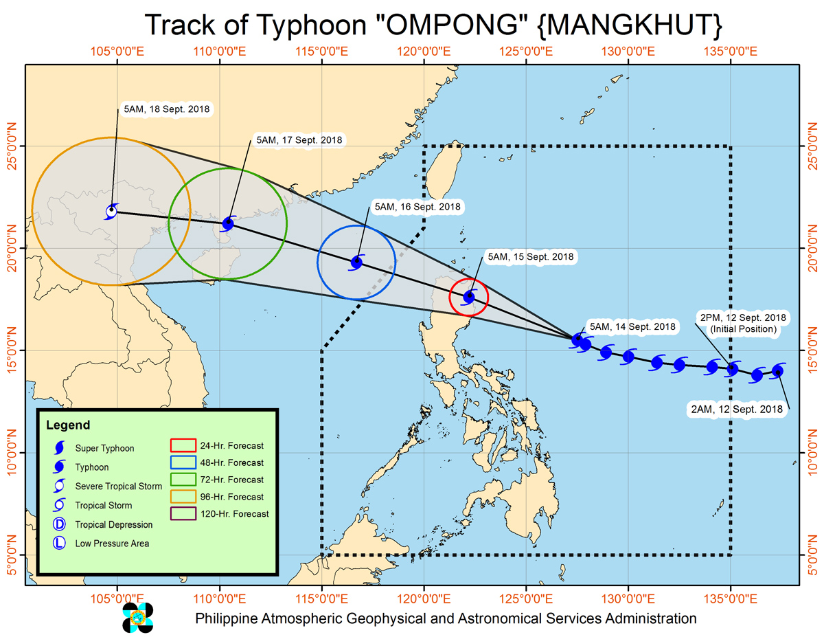
MANILA More areas in Northern Luzon were placed under signal number 3 as Typhoon Ompong kept its strength while moving towards the IsabelaCagayan area, the state weather bureau said Friday.
MANILA More areas in Northern Luzon were placed under signal number 3 as Typhoon Ompong kept its strength while moving towards the IsabelaCagayan area, the state weather bureau said Friday.
The typhoon, packing winds of 205 kph near the center and gustiness of up to 255 kph, is moving northwest at 20 kph and expected to make a landfall around 5 am to 8 am on Saturday, PAGASA said in its weather bulletin published at 11 am.
The typhoon, packing winds of 205 kph near the center and gustiness of up to 255 kph, is moving northwest at 20 kph and expected to make a landfall around 5 am to 8 am on Saturday, PAGASA said in its weather bulletin published at 11 am.
The following areas can feel winds of up to 170 kph in the next 18 hours:
The following areas can feel winds of up to 170 kph in the next 18 hours:
- Cagayan incl. Babuyan group of Is.
- Apayao
- Abra
- Kalinga
- Mountain Province
- Ifugao
- Nueva Vizcaya
- Quirino
- Northern Aurora
- Isabela
- Cagayan incl. Babuyan group of Is.
- Apayao
- Abra
- Kalinga
- Mountain Province
- Ifugao
- Nueva Vizcaya
- Quirino
- Northern Aurora
- Isabela
The weather will be stormy in those areas, said forecaster Chris Perez. Tropical cyclone warning signal 3 can also create moderate to heavy damage, according to the bureau's scale. It also warned that waves may be higher than 14 meters and that storm surges are possible in coastal areas.
The weather will be stormy in those areas, said forecaster Chris Perez. Tropical cyclone warning signal 3 can also create moderate to heavy damage, according to the bureau's scale. It also warned that waves may be higher than 14 meters and that storm surges are possible in coastal areas.
ADVERTISEMENT
These areas, under tropical cyclone warning number 2, will experience stormy weather and winds of up to 120 kph in the next 24 hours:
These areas, under tropical cyclone warning number 2, will experience stormy weather and winds of up to 120 kph in the next 24 hours:
- Batanes
- Ilocos Norte
- Ilocos Sur
- La Union
- Benguet
- Pangasinan
- Tarlac
- Nueva Ecija
- Southern Aurora
- Northern Zambales
- Batanes
- Ilocos Norte
- Ilocos Sur
- La Union
- Benguet
- Pangasinan
- Tarlac
- Nueva Ecija
- Southern Aurora
- Northern Zambales
Winds of up to 60 kph will be felt in the following areas, under signal number 1:
Winds of up to 60 kph will be felt in the following areas, under signal number 1:
- Southern Zambales
- Pampanga
- Bulacan
- Bataan
- Rizal
- Metro Manila
- Cavite
- Batangas
- Laguna
- Quezon incl. Polillo Island
- Northern Occidental Mindoro incl. Lubang Island
- Northern Oriental Mindoro
- Masbate
- Marinduque
- Camarines Norte
- Camarines Sur
- Catanduanes
- Albay
- Sorsogon
- Burias and Ticao Islands
- Northern Samar
Ompong's size of circulation was estimated to be 1,010 kilometers, according to data published by Weather Philippines Foundation at 6:45 am.
Ompong's size of circulation was estimated to be 1,010 kilometers, according to data published by Weather Philippines Foundation at 6:45 am.
The typhoon, expected to barrel towards the Northern IsabelaSouthern Cagayan where it will make landfall, will be weaker than Supertyphoon Yolanda (Haiyan), but it will still be catastrophic, said Mike Padua, senior typhoon specialist at the the agency.
The typhoon, expected to barrel towards the Northern IsabelaSouthern Cagayan where it will make landfall, will be weaker than Supertyphoon Yolanda (Haiyan), but it will still be catastrophic, said Mike Padua, senior typhoon specialist at the the agency.
Ompong will be more comparable to supertyphoon Lawin (Haima) which also hit northern Luzon in October 2016, he told ANC's Headstart. Lawin killed at least 8 people in its wake.
Ompong will be more comparable to supertyphoon Lawin (Haima) which also hit northern Luzon in October 2016, he told ANC's Headstart. Lawin killed at least 8 people in its wake.
Visit the ABSCBN Weather Center for the latest weather updates.
ADVERTISEMENT
ADVERTISEMENT