Welcome, Kapamilya! We use cookies to improve your browsing experience. Continuing to use this site means you agree to our use of cookies. Tell me more!
Resumption of SEA Games events stalled by weather 'very ideal' on Wednesday: PAGASA
ABS-CBN News
Published Dec 03, 2019 04:23 PM PHT
MANILA - The resumption of disrupted Southeast Asian Games events will be "very ideal" on Wednesday, the state weather bureau said Tuesday afternoon.
This as weather in most parts of Luzon will "generally improve" by Wednesday morning as Typhoon Tisoy is expected to approach the West Philippine Sea on Tuesday evening, according to PAGASA weather specialist Benison Estareja.
"Very ideal na mag-resume tayo ng SEA Games activities (bukas), especially dito sa may Calabarzon," he said.
(It's very ideal to resume SEA Games activities tomorrow especially in Calabarzon.)
ADVERTISEMENT
"May sunny periods na po tayo dito sa Metro Manila bukas kaya hindi siya nire-recommend na mawalan ng pasok bukas," he added.
(We already have sunny periods in Metro Manila tomorrow that's why it's not recommended to suspend classes tomorrow.)
Central Luzon, however, will still experience cloudy skies due to the frontal system or the boundary between air masses with different temperatures.
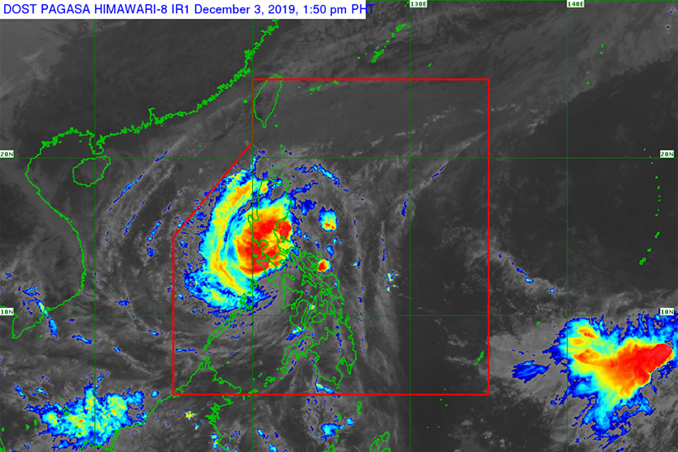
The powerful typhoon further weakened as it made a fourth landfall in Baco town, Oriental Mindoro at noon Tuesday, Estareja said.
As of 1 p.m., the eye of the typhoon was last located in the vicinity of Baco, Oriental Mindoro, packing maximum winds of 140 kilometers per hour and gusts of up to 195 kph.
ADVERTISEMENT
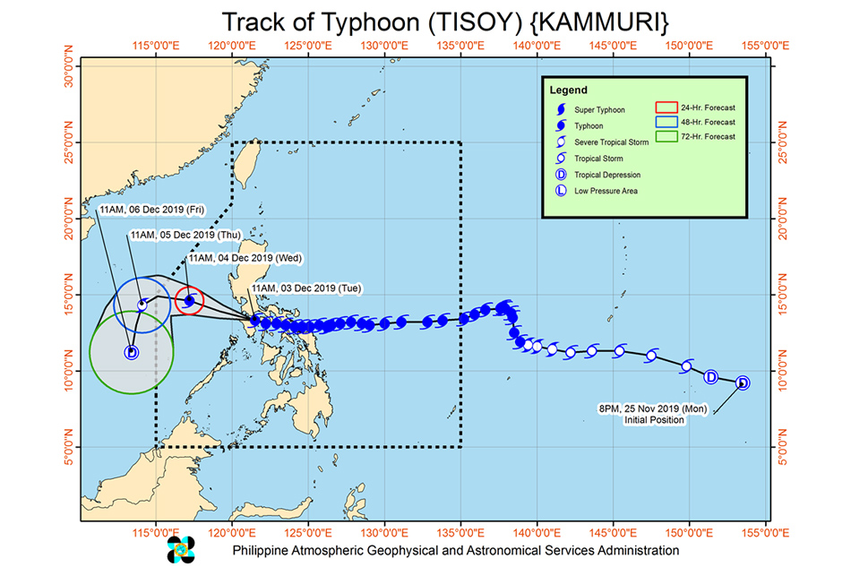
It is forecast to reach 615 kms west of Subic, Zambales on Thursday morning and leave the Philippine area of responsibility as a severe tropical storm.
Frequent to continuous heavy to intense rains will hit Mindoro provinces, Metro Manila, Central Luzon, Rizal, and Northern Quezon including Polillo Islands between late afternoon Tuesday and evening, PAGASA said.
Cagayan Valley, Cordillera Administrative Region, Marinduque, Romblon and the rest of Calabarzon will experience occasional heavy rains, while Calamian Islands in Palawan will get intermittent heavy rains, the agency added.
Storm surges of up to 3 meters may hit coastal areas in Marinduque, Mindoro Provinces, Romblon, Cavite, and Batangas, PAGASA warned.
Track of Typhoon Tisoy. PAGASA
Tropical cyclone wind signals remain hoisted over the following areas:
ADVERTISEMENT
• Signal number 3, where wind speeds of 121 to 170 kph may be experienced within 18 hours
- Southern portion of Quezon (Sampaloc, Lucban, Tayabas, Pagbilao, Lucena, Sariaya, Candelaria, Dolores, Tiaong, San Antonio) - Marinduque - Oriental Mindoro - Occidental Mindoro including Lubang Island - Batangas - Cavite - Laguna
• Signal number 2, where wind speeds of 61 to 120 kph may be experienced within 24 hours
- Metro Manila - Burias Island - Romblon - northern portion of Camarines Sur ( Cabugao, Libmanan, Pamplona, Pasacao, Sipocot, Lupi, Ragay, Del Gallego) - Camarines Norte - Bulacan - Bataan - Tarlac - Pampanga - Nueva Ecija - southern Aurora (Dipaculao, Maria Aurora, Baler, San Luis, Dingalan) - Rizal - rest of Quezon including Polillo Islands - Calamian Islands (Coron, Busuanga, Culion, Linapacan) - Zambales - Pangasinan - Northen Aklan (Malay, Buruanga, Nabas, Ibajay) - northern Antique (Caluya, Libertad, Pandan)
• Signal number 1, where wind speeds of 30 to 60 kph may be experienced within 36 hours
ADVERTISEMENT
- Southern Isabela - Benguet - Nueva Vizcaya - La Union - Quirino - rest of Aurora - northern portion of Palawan (El Nido, Taytay, Araceli, Dumaran), rest of Camarines Sur, Cuyo Islands (Cuyo, Magsaysay, Agutaya) - Masbate including Ticao Island - Albay - Sorsogon - Catanduanes - Western portion of Northern Samar - northwestern portion of Samar (Calbayog, Tagapul-am, Almagro, Sto. Niño) - Capiz - Iloilo - rest of Aklan - rest of Antique
The typhoon prompted the cancellation of flights, government work and classes in several areas.
ABS-CBN is the leading media and entertainment company in the Philippines, offering quality content across TV, radio, digital, and film. Committed to public service and promoting Filipino values, ABS-CBN continues to inspire and connect audiences worldwide.
Our website is made possible by displaying online
advertisements to our visitors. Please consider supporting
us by disabling your ad blocker on our website.
Our website is made possible by displaying online
advertisements to our visitors. Please consider supporting
us by disabling your ad blocker on our website.