LPA develops into 'Chedeng' but rains unlikely | ABS-CBN


ADVERTISEMENT

Welcome, Kapamilya! We use cookies to improve your browsing experience. Continuing to use this site means you agree to our use of cookies. Tell me more!
LPA develops into 'Chedeng' but rains unlikely
LPA develops into 'Chedeng' but rains unlikely
ABS-CBN News
Published Jun 06, 2023 12:38 PM PHT
|
Updated Jun 06, 2023 06:32 PM PHT
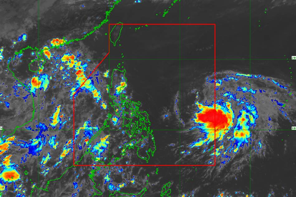
MANILA — The low-pressure area (LPA) located off Eastern Visayas has developed into Tropical Depression Chedeng, PAGASA said Tuesday.
MANILA — The low-pressure area (LPA) located off Eastern Visayas has developed into Tropical Depression Chedeng, PAGASA said Tuesday.
In its latest bulletin issued 11 a.m., the state weather bureau last spotted Chedeng in the eastern Philippine Sea about 1,170 kilometers east of Southeastern Luzon.
In its latest bulletin issued 11 a.m., the state weather bureau last spotted Chedeng in the eastern Philippine Sea about 1,170 kilometers east of Southeastern Luzon.
It was packing winds of 45 kilometers per hour near the center and 55 kph gusts, with "almost stationary" movement reported.
It was packing winds of 45 kilometers per hour near the center and 55 kph gusts, with "almost stationary" movement reported.
While it may further intensify into a tropical storm by Wednesday, PAGASA said Chedeng was unlikely to directly bring heavy rainfall to any part of the country as it is forecast to remain far from the Philippine landmass. Wind signals were also unlilkely.
While it may further intensify into a tropical storm by Wednesday, PAGASA said Chedeng was unlikely to directly bring heavy rainfall to any part of the country as it is forecast to remain far from the Philippine landmass. Wind signals were also unlilkely.
ADVERTISEMENT
It is expected to enhance the southwest monsoon (habagat) and may bring rains to parts of the country, although the areas that would be affected, timing, and intensity may still change.
It is expected to enhance the southwest monsoon (habagat) and may bring rains to parts of the country, although the areas that would be affected, timing, and intensity may still change.
"A weather advisory will be issued by PAGASA should there be an increasing chance of monsoon heavy rainfall within the next three days," the state weather bureau added.
"A weather advisory will be issued by PAGASA should there be an increasing chance of monsoon heavy rainfall within the next three days," the state weather bureau added.
Chedeng is also forecast to become a typhoon by Thursday, reaching its peak intensity in the weekend while over the Philippine Sea east of northern Luzon.
Chedeng is also forecast to become a typhoon by Thursday, reaching its peak intensity in the weekend while over the Philippine Sea east of northern Luzon.
It is the third tropical cyclone to enter the Philippine area of responsibility (PAR) this year, after Tropical Depression Amang last April and Typhoon Betty last month.
It is the third tropical cyclone to enter the Philippine area of responsibility (PAR) this year, after Tropical Depression Amang last April and Typhoon Betty last month.
Visit the ABS-CBN Weather Center for more updates.
RELATED VIDEO:
ADVERTISEMENT
ADVERTISEMENT